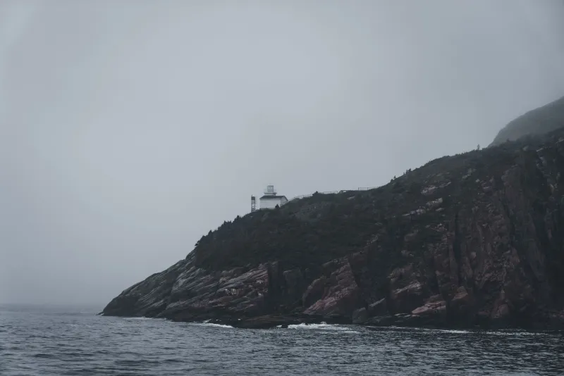
Here is a thing that should not be possible in the modern era of satellite mapping, GPS coordinates, and international treaty law: a working lighthouse, maintained by the United States government, staffed by American personnel, and flying an American flag, sitting on land that technically belongs to Canada.
And yet.
How You Draw a Line Badly Enough to Lose a Building
The U.S.-Canada border is the longest international boundary in the world — nearly 5,525 miles of line that cuts through forests, lakes, prairies, and mountains. Drawing it required decades of surveys, dozens of treaty negotiations, and an almost heroic amount of paperwork. Given all of that, it's perhaps not surprising that a few errors crept in.
What is surprising is how those errors were handled once discovered.
The specific lighthouse in question sits in a remote stretch of the northern border region where the boundary was established by treaty language that described the line in terms of geographic features — rivers, ridgelines, water channels — rather than precise coordinates. This was standard practice for 19th-century diplomacy. It was also, as surveyors discovered much later, a method that left considerable room for interpretation.
When more accurate surveys were conducted in the early 20th century using improved instruments and techniques, officials on both sides of the border began noticing that certain structures didn't quite line up where the maps said they should. Most of these discrepancies were minor — a fence post here, a property line there. A few were more significant.
The lighthouse was one of the significant ones.
The Discovery Nobody Wanted to Make Official
According to accounts pieced together from border commission records and archival correspondence, the jurisdictional problem with the lighthouse was identified by surveyors working on a routine boundary clarification project. Their calculations showed clearly that the structure — built by the United States, operated by the United States, and considered by everyone in the vicinity to be unambiguously American — sat on the wrong side of where the treaty line actually ran.
This finding made its way up through the appropriate bureaucratic channels on both sides of the border, where it was met with something that can only be described as enthusiastic reluctance.
Fixing the problem would have required renegotiating the relevant treaty provisions, which would have meant opening up a much larger set of boundary questions that both governments had spent considerable energy settling. It would have required transferring the lighthouse to Canadian jurisdiction, which raised questions about compensation, operational continuity, and what exactly American sailors were supposed to do with a navigational aid that was no longer American. It would have required, in short, an enormous amount of work to solve a problem that wasn't actually causing anyone any immediate harm.
Both governments looked at the math, looked at each other, and looked back at the math.
Then they filed the survey reports in separate archives and moved on.
Life at the World's Most Complicated Lighthouse
For the keepers who worked the lighthouse over the decades that followed, the jurisdictional strangeness ranged from mildly amusing to genuinely inconvenient, depending on who you asked.
Some keepers apparently knew about the discrepancy and treated it as a conversation piece — the kind of arcane institutional knowledge that gets passed down informally, outside of any official briefing. Others seemed entirely unaware. The lighthouse did its job regardless: it warned ships away from dangerous coastline, it operated on American schedules and American budgets, and it was serviced by American crews who drove American government vehicles to get there.
The fact that they were, technically, crossing an international border in the process was something everyone involved found easier to not think about too hard.
Local residents in the border region were often more aware of the situation than the federal officials nominally responsible for it. In small communities straddling the U.S.-Canada line, the lighthouse's ambiguous status became a piece of local lore — the kind of story that gets told at diners and hardware stores, with varying degrees of embellishment, to anyone who seems like they might find it interesting.
The Art of the Diplomatic Non-Answer
What makes the lighthouse story remarkable isn't just the error itself — boundary mistakes happen, and history is full of them. What's remarkable is the response to the error, which was essentially to construct an unspoken mutual agreement to pretend the problem didn't exist.
Both the U.S. and Canadian governments are perfectly capable of resolving border disputes when they want to. They've done it many times. The International Boundary Commission exists specifically to manage exactly these kinds of issues. The machinery for a fix was always there.
The decision not to use it was a conscious one, even if it was never written down anywhere as a formal policy. And in its own strange way, it worked. The lighthouse kept functioning. Ships kept navigating safely. The border question stayed quietly, comfortably unresolved.
There's a lesson buried somewhere in there about the gap between how governments are supposed to operate and how they actually do — about the number of official problems that get solved not by action but by collective agreement to stop looking at them directly.
The lighthouse, for its part, just keeps flashing its light out into the dark water, indifferent to which country it belongs to, doing exactly what it was built to do.